
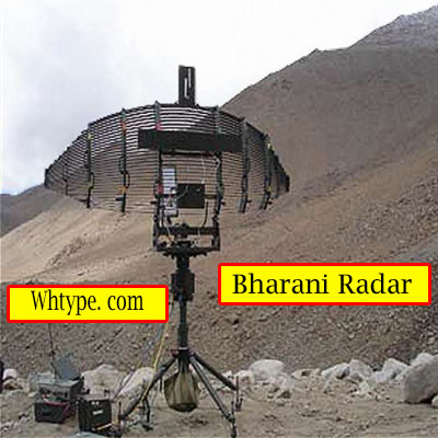
✅ Bharani Radar – Low-Level Lightweight Radar (LLLR)
Read In English/हिन्दी में पढ़ें
🔷 Introduction
Bharani Radar is an indigenous low-level lightweight 3D radar developed by DRDO’s LRDE (Electronics and Radar Development Establishment). It is designed to detect and track low-flying aerial targets such as UAVs, helicopters, and low-altitude aircraft in mountainous and rugged terrain. It is used by the Indian Army, especially in high-altitude border regions.
🔷 Key Facts
| Feature | Details |
|---|---|
| Name | Bharani Radar |
| Type | Low-Level Lightweight 3D Radar |
| Developed By | DRDO – LRDE |
| User | Indian Army |
| Main Role | Detection of low-altitude threats (UAVs, helicopters, aircraft) |
| Deployment Areas | Mountainous and remote terrain |
| Mobility | Man-portable / Vehicle-mounted |
| Range | ~40–50 km |
| Altitude Coverage | Low Altitude (~3–4 km) |
🔷 Key Features
- Lightweight and portable – Can be carried and deployed by soldiers.
- 3D Surveillance – Provides range, azimuth (direction), and height data.
- Quick Deployment – Fully operational in under 10 minutes.
- IFF Capable – Includes Identification Friend or Foe system.
- Designed for High Altitudes – Effective in mountainous and extreme weather conditions.
- Low Power Consumption – Operates on battery or vehicle power.
- Detects Low RCS Targets – Effective against small drones and stealthy aerial threats.
🔷 Operational Use
- Tracking of low-flying aerial intrusions in border and high-altitude regions.
- Provides early warning to air defense units.
- Supports target acquisition for anti-aircraft guns and missile systems.
- Operates in tactical forward areas, including hilly terrain and conflict zones.
🔷 Technical Specifications
| Parameter | Value |
|---|---|
| Detection Range | 40–50 km |
| Target Type | UAVs, helicopters, low-altitude aircraft |
| Mobility | Man-portable or mounted on a light vehicle |
| Setup Time | < 10 minutes |
| Environment | Works in harsh, high-altitude conditions |
🔷 Comparison with Other Indian Radars
| Radar | Type | User | Range | Platform |
|---|---|---|---|---|
| Bharani | LLLR 3D Radar | Indian Army | ~50 km | Ground, portable |
| Rohini | Medium Range 3D Radar | Army/Air Force | ~180 km | Ground-based |
| Revathi | Naval 3D Radar | Indian Navy | ~200 km | Shipborne |
🔷 Conclusion
The Bharani Radar is a significant asset for the Indian Army in early detection and air surveillance, especially in difficult terrains like the Himalayas. Its lightweight, fast deployment, and high accuracy make it an essential part of India’s tactical air defense infrastructure.
✅ Bharani Radar – भरनी रडार प्रणाली
Read In English/हिन्दी में पढ़ें
🔷 परिचय (Introduction)
Bharani Radar भारत का एक Low-Level Lightweight Radar (LLLR) है, जिसे विशेष रूप से दुर्गम और ऊँचे पर्वतीय इलाकों में दुश्मन के कम ऊँचाई वाले हवाई लक्ष्यों (Low Flying Targets) की पहचान और ट्रैकिंग के लिए डिज़ाइन किया गया है। यह रडार पूरी तरह से स्वदेशी है और DRDO द्वारा विकसित किया गया है।
🔷 मुख्य तथ्य (Key Facts)
| विशेषता | विवरण |
|---|---|
| नाम | Bharani Radar (भरनी रडार) |
| प्रकार | Low-Level Lightweight 3D Radar |
| विकासकर्ता | DRDO – LRDE (Electronics and Radar Development Establishment) |
| प्रयोगकर्ता | भारतीय थलसेना (Indian Army) |
| मुख्य उद्देश्य | दुश्मन के UAV, हेलीकॉप्टर और कम ऊंचाई पर उड़ने वाले विमानों की पहचान |
| स्थान | पहाड़ी और दुर्गम क्षेत्रों में तैनात किया जाता है |
| मॉबिलिटी | Man-portable (सैनिकों द्वारा ले जाया जा सकता है) |
| कवरेज रेंज | लगभग 40–50 किलोमीटर तक |
| ऊंचाई कवरेज | Low Altitude – लगभग 3–4 किमी तक |
🔷 मुख्य विशेषताएँ (Key Features)
- हल्का और पोर्टेबल – सैनिकों द्वारा पैदल भी ले जाया जा सकता है।
- 3D Surveillance Capability – दूरी, दिशा और ऊंचाई की जानकारी।
- Quick Deployment – कुछ ही मिनटों में तैनात किया जा सकता है।
- IFF (Identification Friend or Foe) प्रणाली से युक्त।
- उच्च ऊँचाई वाले क्षेत्रों (High Altitude Areas) में संचालन के लिए अनुकूल।
- Battery/Vehicle Power Operable – सीमित संसाधनों में भी कार्य करता है।
- Low RCS Target Detection – छोटे लक्ष्यों जैसे ड्रोन की पहचान में सक्षम।
🔷 प्रयोग और महत्त्व (Operational Importance)
- दुश्मन के हेलीकॉप्टर, ड्रोन, और निम्न ऊँचाई वाले फाइटर जेट की पहचान।
- पहाड़ी सीमाओं (जैसे LAC, LOC) पर निगरानी।
- एयर डिफेंस गन या मिसाइल सिस्टम को लक्ष्य डेटा प्रदान करना।
- “Early Warning” अलार्म सिस्टम के रूप में कार्य करता है।
🔷 तकनीकी जानकारी (Technical Details)
| पैरामीटर | विवरण |
|---|---|
| Detection Range | 40–50 किमी तक |
| Target Types | UAV, Helicopters, Low Altitude Aircraft |
| Portability | Man-portable या Vehicle-mounted |
| Deployment Time | 10 मिनट से कम |
| Operating Environment | Extreme temperatures और high altitudes में काम करने में सक्षम |
🔷 अन्य रडार से तुलना (Bharani vs Rohini vs Revathi)
| रडार | प्रकार | प्रयोगकर्ता | रेंज | स्थान |
|---|---|---|---|---|
| Bharani | Low-Level Lightweight | थलसेना | ~50 किमी | पहाड़ी क्षेत्र |
| Rohini | Medium Range 3D Radar | थलसेना/वायुसेना | ~180 किमी | मैदान/बेस |
| Revathi | Naval 3D Radar | नौसेना | ~200 किमी | युद्धपोत |
🔷 निष्कर्ष (Conclusion)
Bharani Radar भारत के लिए रणनीतिक रूप से बहुत महत्वपूर्ण है क्योंकि यह सीमित संसाधनों और कठिन परिस्थितियों में भी दुश्मन के हवाई खतरों की पहचान करने में सक्षम है। इसका स्वदेशी निर्माण, हल्का डिज़ाइन और तेज़ी से तैनात होने की क्षमता भारतीय सेना को एक मजबूत सामरिक बढ़त प्रदान करती है।
Learn More


Leave a comment